How many times have you walked the block on 102nd street between Broadway and Amsterdam and noticed 202 West 102nd and the odd angle it takes. If you stand on the north side of the street and look straight into the lobby of the building, you are facing real south, not downtown. Conversely, if you are coming out of the building you would be heading due north as you promenaded through the lobby. So why?
This building is at such an angle that it almost looks like a flat. The eastern wall in this garage follows the same contours that this building does.
This is the 1867 map and what appears to be Broadway is not, it is the Bloomingdale Road. The footprint of Broadway is visible to the west, or left, of the Road. As the Road takes a turn to head due north it is cutting, at an angle, through 102nd street. Today, where the road took that turn is in between Broadway and Amsterdam. At the top of the map where it says "Ward School" is the site of the playground outside P.S. 145. and is the first of what will eventually be 3 school buildings on the site.
This the 1885 map and The Boulevard is in place and it appears that The Road has been rendered obsolete. There are undeveloped lots now in the footprint of The Road and for some reason the lots on the south side follow the contours of the road. There is nothing on either side and still the abandoned Bloomingdale Road is dictating the shape of things to come.
This is the map from 1911 indicating the current 202 West 102nd street. Broadway is there in it's current location and the Road has been reduced to dotted lines with a blue tint and a building at an angle. The Hotel Clendining is there at 103rd and Amsterdam and the 442 seat Rose Theater east of Amsterdam showed movies until it closed around 1942. But was it showing movies in 1911?
“Is it not cruel to let our city die by degrees, stripped of all her proud monuments, until there will be nothing left of all her history and beauty to inspire our children? . . . this is the time to take a stand, to reverse the tide, so that we won’t all end up in a uniform world of steel and glass boxes.” - Jacqueline Kennedy Onassis
Showing posts with label Bloomingdale Road. Show all posts
Friday, March 28, 2014
Friday, April 5, 2013
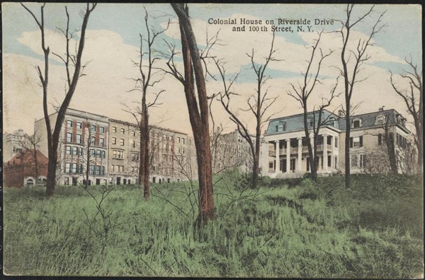
The Upper West Side's "Colonial House" in Color.
Often referred to as the "Colonial White House",probably because of the columns and the colorof the house, this mansion was important enough to merit it's own postcard. Built by the dry goods wholesaler William P. Furniss, the house was on land once owned by Charles Apthorpe. Apthorpe's estate once upon a time stretched from 99th street down to 81rst street, from Riverside Drive to Central Park West. In 1764 he sold a large chunk to Jacob Stryker. This piece included 96th street and the cove that used to be there was called Striker's Bay (spelling's and politician very often are corrupted. 100 years earlier the land was owned by Theunis Idens van Huyse, a Dutch tobacco farmer who once was the largest landowner on the island of Manhattan.
The Furniss estate briefly extended up to 104th street and Riverside Drive, and it did extend all the way to the edge of the Hudson River, but over the years lots were sold off or given away to his children and the construction of Riverside Drive cut off the river access. Furniss and his wife had passed away by 1880, their daughter Margaret sold the lots south of what is now 99th street to John N. A. Griswold of Newport, Rhode Island. Then in 1899 Griswold sold the lots, which had remained undeveloped during his ownership. This left a still ample piece of property for an already vastly different city from when the house first went up - the entire block from 99th street to 100th street from West End Avenue down to Riverside Drive.
This is a piece of the 1867 map and the house is clearly indicated on its eventual plot / block of land. On this map, the only indication that the estate stretched up to 104th street is a piece of property labeled "Furniss" on what is now the middle of West End Avenue at 103rd street down to the Bloomingdale Road / Broadway.
Eventually the old Furniss mansion had become an artist’s colony of sorts. A playwright by the name of Paul Kester lived in the house during its final years and would very often hold rehearsals in the big living room. Gertrude Stein lived in the Furniss house from February to late spring 1903. The Furniss house finally gave way to the ever growing city, apartment house construction and the old saying "the land is worth more than the house". The Old Colonial White House" was torn down in 1904.
The Furniss estate briefly extended up to 104th street and Riverside Drive, and it did extend all the way to the edge of the Hudson River, but over the years lots were sold off or given away to his children and the construction of Riverside Drive cut off the river access. Furniss and his wife had passed away by 1880, their daughter Margaret sold the lots south of what is now 99th street to John N. A. Griswold of Newport, Rhode Island. Then in 1899 Griswold sold the lots, which had remained undeveloped during his ownership. This left a still ample piece of property for an already vastly different city from when the house first went up - the entire block from 99th street to 100th street from West End Avenue down to Riverside Drive.
This is a piece of the 1867 map and the house is clearly indicated on its eventual plot / block of land. On this map, the only indication that the estate stretched up to 104th street is a piece of property labeled "Furniss" on what is now the middle of West End Avenue at 103rd street down to the Bloomingdale Road / Broadway.
Eventually the old Furniss mansion had become an artist’s colony of sorts. A playwright by the name of Paul Kester lived in the house during its final years and would very often hold rehearsals in the big living room. Gertrude Stein lived in the Furniss house from February to late spring 1903. The Furniss house finally gave way to the ever growing city, apartment house construction and the old saying "the land is worth more than the house". The Old Colonial White House" was torn down in 1904.
Friday, March 22, 2013
Riverside Drive at looking south from 109th street - nothing lasts forever in this town.
The future, and temporary Riverside Avenue, as it will be quickly renamed Riverside Drive. The Drive was under construction while lawsuits over land ownership and eminent domain abuse were litigated. One guess who won. This is looking south on September 30th 1870 from 109th Street. Obviously much has changed but there is so much that is recognizable today. None of the houses are with us but the shape of the island of greenery (the tangled mess of bushes and trees) between the service road and the main drive is starting to look familiar. The service road does not exist on the 1867 maps and neither do these houses. There are houses that unfortunately do not appear in this photo but do appear, along with their drive ways, on the 1867 map. What will become the service road is merely a suggestion at this point. The hill leading down from 106th street to the intersection of the service road and 108th street where the shortest timed traffic light on the west side is placed is already evident. Where the wagon with the big wheel in the middle of the drive is sitting is 108th street. In such a short period of time, massive change will happen.
Built in 1892 for Samuel Gamble Bayne (1844- 1924 ), the son of a prosperous merchant in the town Ramelton, Ireland. At the age of twenty-five Sam graduated from Queen's University Belfast and decided to travel to America. While he was here Samuel G. Bayne accumulated enough wealth to join the billionaires club. His wealth was based on gold prospecting in California, oil in Texas and banking; he was a founder of Seaboard National Bank, which ultimately after several mergers and acquisitions became what we all know and love today - Chase Manhattan Bank (now JP Morgan Chase). Could that be the nearly 80 year old Bayne sitting on the steps?
If his house was here still, if you crazy enough to have a car on this island and in this neighborhood, you would probably spend some time waiting for a green light in front of it. Not an unpleasant site to sit in front of.
Friday, March 15, 2013
Once there was a valley, Clendening Valley.
I love this print. Look how happy everyone appears to be; the mother with her parasol, the father in his best top hat strolling along holding his son's hand. The girl playing with a hoop and the couple promenading north on Second Avenue at 42nd Street in 1861 have an air of contentment. But the house up on that cliff looks precarious. As soon as Europeans showed up on Manahatta, the task of taming the island began. As the city grew in population and the boundary inched ever northward, more and more of the original landscape disappeared into oblivion in the name of progress. Forests felled, streams filled in, swamps drained and hills leveled. And when we imposed a grid upon the island, all of those streets, all of those right angles were cut through making the streets level. After all, it was a horse drawn world when the grid was being cut through those hills, and would it not be easier on the beasts if they had a level path. This scene was all too common and those streets that were cut through were very often muddy gullies, not the idyllic scene with a house that could fall over any second presented here. This is a great record of a great city undergoing yet another transformation. However some hills could not be tamed, especially if the word "valley" is attached. Manhattan Valley, where the subway was forced to come out of the ground as it dropped, only to go back into a tunnel as it rose again; and Clendening Valley which centered on Columbus Avenue approximately between 104th street all the way to 94th street with 96th street the bottom of the valley.
This is the Clendening Mansion. This print from Valentine's Manual lists the location as 90th Street and 8th Avenue. This is incorect. John "Lord" Clendening was a wealthy New Yorker who made his fortune importing Irish textiles after the Revolution, at the end of the 18th century. He built this lovely mansion, complete with widow's walk and waving American flag, around 1811. It stood at what is now the southwest corner of Amsterdam Avenue and 103rd Street, in the northern fringes of the area known as Bloomingdale. As the grew, so did the demand for a clean reliable water source. Early New Yorkers were incredibly dumb when it came to clean drinking water. They were very adept at polluting their water sources. Finally someone put it together and figured that all the garbage strewn ponds and wells (some wells too close to cemeteries that contained the bodies of those who had died in cholera epidemics) were killing them. Long story short, and it is a long story, after building the Erie Canal system nothing seemed impossible. So supervised by Chief Engineer John B Jervis (like in Port Jervis, who had served as one of the engineers of the Canal system) an aqueduct system was designed to bring water from reservoirs in Westchester County all the way down to City Hall Park. Bringing water by the force of gravity alone, New York City's first aqueduct system sent water 41 miles through stone aqueducts which for the most part were underground. Except in Clendening Valley. Because of the dip in the landscape a plan had to be hatched.
This is what they were going to look like. However the "Whig" party had gained control of the state legislature. This party was against wasting taxpayer money on arches through an aqueduct as they were firm believers in less government and lower taxes. They won their fight to scrap the idea of arches in favor of a solid wall of Manhattan Schist running the entire length of the valley. Realizing the obvious, an unbroken wall would be a barrier to development, in the first veto ever by a New York City mayor, Democrat Isaac Varian prevented the walling up of the valley . A compromise was reached and the wall was to passable in three places - at 98th, 99th, and 100th streets. The wall completely blocked the paths of the future 96th, 97th, and 101st Streets.
There are the arches on the map from 1868. The streets and sidewalks of 98th, 99th, and 100th streets passed beneath those arches. The Clendening estate stretched from the north side of 99th Street to the south side of 105th Street and from Central Park West to the Bloomingdale Road. The estate was lost in 1845 and the farm disappeared within 20 years. By the 1870s, development demanded more water; the above ground aqueduct section was buried underground into a pipe siphon and the solid wall blocking 96th, 97th, and 101st Streets–along with the arched 98th, 99th and 100th streets - was torn down.
Again, the map from 1868. The name John Clendening appears on the map although Clendening had lost the land years earlier. The diagonal line from where the aqueduct crosses west 105th street south west to just south of 103rd street and then west was called Clendening lane. The lane ran over to the plot of land that was the site of the old Downes Boulevard Hotel on 103rd street and the Boulevard (now Broadway). There are remnants of the intersection of the lane and the aqueduct on the south side of 105th street between Amsterdam and Columbus Avenues just east of P.S. 145. Best to observe it using bing or google maps.
This is looking northeast from just south of 101rst street between Amsterdam and Columbus Avenues. The 104th Street 9th Avenue El station is in the distance and the remains of the aqueduct through Clendening Valley are in the left foreground. This is quite possibly the remains of the arch-way at 101rst street. The original Croton Aqueduct, one of the most important pieces of what made New York City, opened June 22, 1842, taking 22 hours for gravity to move the water the 41 miles to Manhattan. Almost immediately it was woefully inadequate. Construction on a new aqueduct began in 1885. The new aqueduct, buried much deeper than the old one, went into service in 1890, with three times the capacity of the Old Croton Aqueduct.
Clendening lived on his rural estate for many years, but in 1836 he lost most of his money when President Andrew Jackson refused to renew the charter of the United States Bank, in which Clendening was a major stockholder. The estate was sold in 1845 as forty lots for a total of $4500. Although the mansion was torn down the area was known as Clendening Valley well into the post civil war 19th century New York. On the site where Lord Clendening's house one stood, the Clendening Hotel rose in its place on the west side of Amsterdam Avenue at 103rd street. The Hotel survived until 1965 when it was torn down for furthest west building of the Douglas Houses complex.
Wednesday, March 14, 2012
The Doctor's Summer Home - Broadway and 94th Street
This is Doctor Valentine Mott. Born in Glen Cove Long Island in 1785, the good doctor went on to be called, some circles, the father of American vascular surgery. He was an artist and a pioneer on this new frontier of surgery. He was a firm believer in anesthesia, which he championed stating that "pain is the only evil" and that anesthesia was safe if administered correctly. Doctor Mott was also ambidextrous, a helpful trait in the pre-anesthesia world of surgery. You wanted a surgeon who was good with both hands at the same time as it sped up the procedure. Although there is a Mott Street here in Manhattan, it is named after Joseph Mott, a local butcher and tavern owner who provided support to the patriots during the American Revolution. Doctor Mott, though, did all right.
This is the doctor's summer home. Although the Mott's owned a still extant townhouse at 1 Gramercy Park, this is where he spent a few summers. The village of Bloomingdale retained it's rural character even after the Civil War. The house, built in 1835, was located on approximately 93rd and the middle Broadway. If this is the Bloomingdale Road, as I believe it is, the house faced east, we (and Victor Prevost who took the picture) are facing west. This view was taken in 1853.
Subscribe to:
Posts (Atom)