Tuesday, November 13, 2012

Neighborhood Nightclub, Park West Village and the death of a man on a bus in New Jersey in 1956


On May 15th 1956, the New York Times ran an obituary of a man who suffered a heart attack and died on a bus. The man was 73 years old and for the past several years had lived in a rooming house in Bloomfield New Jersey, a suburb of Newark.  The article went on to say that in a jacket pocket a note was found directing that in the event of his death the powerful columnist Ed Sullivan (as well as several other newspaper columnists) should be notified. The man was born in Jersey City in 1883 as Herman Hinrichs but he was better known as Will Oakland, a singer who had made a fortune with his high tenor voice and was the idol of the "bobby soxers" of his day. He was the winner of many popularity contests on the 1920's and owned several night clubs in New York. His wealth and night clubs vanished in the stock market crash of 1929 just as his popularity was starting to fade. By 1934 he was filing for bankruptcy while working as a catering hall manager and entertainer in Valley Stream Long Island. He performed at the Palace Theatre in March of 1951.
Having quit school at an early age, he ran away to serve in the army during the Spanish - American War of 1898.  He sang with an Army band, then with a group called Primrose's Minstrels, changing his name at that point. The phonograph and eventually the radio soon established him as a top ballad singer.  And He owned a nightclub on the upper westside.


This is a map from 1911, showing the new Water Department facility and a long row of single family homes interrupted by two small apartment buildings.


This is 97th street at Columbus Avenue looking west in April of 1941. The world was in the brink of war and now all of this is gone. The row houses, two small apartment buildings (visible on the map above), then a few more row houses and then Amsterdam Avenue. The building just to the left of of the 2 story structure with the arches is the local Department of Water facility, servicing the New Croton Aqueduct system of 1890 which originally augmented the Old Croton Aqueduct system of 1842. The old system, which south of 110th street ran along a stone aqueduct between Amsterdam and Columbus Avenues, was woefully inadequate for our ever growing city. It did, however leave us some charming stone gate houses such as the three along Amsterdam Avenue at 113th, 118th and 135th streets. But I digress . . .


Maybe if he spelled Italian correctly, he might have not gone under during the depression. The location is given as "East of Broadway"so I am guessing that there was some sort of negative connotation about highlighting being between the two avenues.
The Winter Garden referred to as "Formerly Winter Garden 'Spice of 1922' " is the Winter Garden Theater, home to Mama Mia for as long as I can remember. 


This is Mr. Anton Lada and his Louisiana Five. Among the earliest jazz groups to record extensively this band was active from right after World War One through the mid 1920's, The Louisiana Five was led by drummer Anton Lada. 


This is the front if 163 and 165 west 97th street.  Chateau Shanley occupied, it appears, the basements of two row houses. Part of this row, 161 - 165 west 97th street, was demolished in 1931.  This site is now occupied by the Alfred E. Smith School, built to accommodate the the large number of new upper westsiders moving into what was going to be called Manhattantown. In one of the many dark moments in New York City history, $15,000,000 worth of real estate was sold to a political insider for $1,000,000 by the Mayor's slum clearance committee, a developer who was ready to build. This committe used to their advantage President Harry Truman's well intentioned The Housing Act of 1949, a slum clearance initiative, to their advantage. All this agency had to do was to declare an area or neighborhood "blighted" or a slum, the next thing you know everyone is being Eminent Domained off their property and out of their homes for the alleged good of the community.  As soon as the idea was on the table in the spring of 1949, allegations of corruption began to fly which eventually lead to hearings in the Senate's Banking and Currency Committee in 1954.  These hearings and the delays of lawsuits put forth by the owners of the property in a large middle class African American community delayed the Zeckendorf's from reaping millions and postponed construction of what became a mostly white middle class enclave called Park West Village. If you think about it too much it looks as if Park West Village is a buffer between everything south of 96th street and the Fredrick Douglas Houses. If you think about it you might ask questions, I have always believed that history is a great deal of dot connecting.

Wednesday, October 10, 2012

Train Stations of Manhattan

Trains station of Manhattan that do not exist any more is probably a better title. The Hudson River Railroad reached Albany by 1851. Cornelius Vanderbilt was told he was crazy putting a railroad so far over on the west side of Manhattan. He said something along the lines of "build it and they will come". I am not suggesting the man had seen Field of Dreams but he saw the future. He was right and a neighborhood sprung up near the tracks, a neighborhood eventually bordered not only by the Hudson River and what became the Hudson Division of the New York Central, but also the 9th Avenue Elevated.

The Harlem River line, the line that runs up what we now call Park Avenue, had passenger stations at 59th street, 86th street and 110th street in addition to the 125th street station. These areas of sparse population were eventually going to grow as the city marched north.  Mr. Vanderbilt's railroad along the Hudson River also saw the potential.  Like the Harlem River Railroad, along the way up the river  passenger stations were built at 96th Street, 130th Street, 152nd Street (for the development called Carmansville) and at Inwood.

 This is a map from 1867. The grid of 1811 is visible in an area that would not see too much in the way of the grid. The tracks are there and so is the station. In 1864 Cornelius Vanderbilt took over the Harlem River Rail Road and another railroad upstate called the New York Central. By 1867, he merged these roads together calling this uber railroad, The New York Central.


Some of the streets are gone or renamed. The grid lines have faded but the station is still there. This is a map from 1897 and the station is called "Inwood or Dyckman Station". The street that we now call Dyckman was once upon a time known as Inwood Street.

This is a map from 1911. Dyckman Street is Dyckman but the memory of it being called Inwood Street lingers, in parenthesis anyway. The station is called Inwood and was still seeing service as a passenger station at this late date. The building in the center would eventually become part of a scandal concerning the abuse of the young women who lived there, poor single girls and a park would eventually envelope the site, but more on that later.

Small town America? Small town Manhattan. I have always said that Manhattan's neighborhoods are like a bunch of small towns strung together by a grid. Harlem was a separate village and so was the village of Greenwich. This is Inwood and this is the station that served the area before there was a subway to fill the rapid transport needs of this community. What is now Dyckman street is on the right and the road going up the hill in the center of the picture is now in Dyckman Field and Inwood Hills Park. The road is gone, the tracks were elevated in the early 1920's and no trace remains of the station.

Thursday, August 2, 2012

Before it is gone . . .


Before it is gone . . .


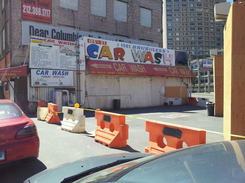
I posted this picture a while ago as part of my 125th street extravaganza.  This period picture looks like it was taken not long after opening.  This is just next to the Riverside Drive Viaduct on what we call incorrectly 125th street.  Ultimately the service station was turned into a car wash.  The station and the car wash fall within the area that Columbia University feels it need to expand into.  


This is the service station as it has look for years.  The car wash stopped operating a few years ago but gas was being sold there up until a few weeks ago.  Above the “menu” the protest banner reads “Dear Columbia: No Forced Displacement”.  The banner is protesting the eviction of the businesses that have called Manhattanville home for years. 

So farewell once upon a time art decoesque service station.  Farewell slightly overpriced gas station and not so hot car wash.  I will miss you, you relic, you reminder of another time when even Manhattan had beautiful gas stations.

Tuesday, June 12, 2012

Medical Institutions on Morningside Heights Part 1

Morningside Heights is know for many things: V & T Pizza, The Hungarian Cafe, Saint John The Divine, Columbia University and Saint Luke's Hospital are some of the many things. These places are also part of what gave  Morningside Heights a very distinct institutional flavor throughout the 19th century.  Beginning in 1821 with New York Hospital's Bloomingdale Insane Asylum (now Columbia University) and the Leaks Watt Orphanage (on the site of Saint John the Divine), the area north of 110th street west of what is now Morningside park was sort of an institutional acropolis. The "Heights" was / is a plateau, public transportation was practically non-existent (except for streetcars) until the subway opened in 1904. The 9th avenue el swung east then north at 110th street and headed in to the plains of Harlem while these institutions were built and gave way to new institutions.

This is the Bloomingdale Insane Asylum. New York Hospital began this institution down in the city proper, on Broadway and Duane Street, across from where our City Hall was eventually built, in pre-revolution New York (the British built city hall was on Wall Street where Federal Hall National Memorial now stands). The city was constantly growing, up the island and New York Hospital began buying land in what is now Morningside Heights (and just a little south of 110th as well) in 1816 and by 1818 had purchased 26 acres.  Using the land uptown would provide ample room for a farm, upon which the patients would work.  Believing that this would be therapeutic, it was incredibly forward thinking as asylums in the early 19th century were not anywhere near as enlightened.  This is only part one, more later.


This is The Woman's Hospital in it's original location, 50th and Park Avenue, now the home to the Waldorf - Astoria.  Built on what was once a burial ground for cholera victims from an 1832 epidemic and after digging up thousands of coffins, the hospital opens in this building in 1867 after starting in a temporary headquarters on Madison Avenue and 29th Street.  The hospital was founded by Doctor J. Marion Sims and Sarah Platt Doremus.  Doctor Sims was, and is, a controversal figure in medical history. Although there is a statue of him in Central Park at 103rd street and Fifth Avenue, even though he is the first physician to depicted in statue form, although he developed a few procedures and had been referred to as the the father of American gynecology, there are some lingering questions about him. Between 1845 and 1849, while working in Alabama, some of the procedures he perfected probably involved subjects who were not given the recent innovation of anesthesia.  Sarah Platt Doremus was a well meaning philanthropist who did a great deal of mission work and in 1860 she founded the Woman's Union Missionary Society, "designed to elevate and Christianize the women of heathen lands".  Her philanthropy extended to homes for aged women to bringing religion to prisons to establishing a home for recently released female convicts.   The railing at the bottom of the print was to separate pedestrians from the tracks of the Harlem River Rail Road.


This is the hospital after it moved to 110th street and Amsterdam Avenue in 1906. This is looking south east and the site is now occupied by a Con Edison substation whose front doors on the Avenue look like the front door to the Land of OZ.
As tarnished (tarnished is being kind) as Doctor Sims background may be, he did fight for women's health issues, advocating for the treatment of cancer.  In 1871 Sims returned to New York (after a very colorful career in Europe), and after quarreling with the board of the Woman's Hospital over the admission of cancer patients, went on to found a new hospital, later to evolve into the Memorial Center for Cancer and Allied Diseases.
Woman's Hospital, the first hospital for women in New York, was eventually absorbed into Saint Luke's Hospital which made the leap to "The Heights" from it's original 1858 home on 54th street and Fifth Avenues to it's new and current home home in 1896.  In 1953 Woman's Hospital became part of Saint Luke's and in 1965 the Woman's Hospital was moved to 114th Street and Amsterdam Avenue, just across the street from St. Luke's. The 1906 building was torn down not long after.

Thursday, May 31, 2012

103rd Street and Broadway (and a little 104th Street)


After the Civil War, New York grew at a rate like never seen before in this town.  The only way New York, and when I say New York I mean the Isle of Manhattan, could grow was up. Up the island. There were pockets of the once rural character left on this rock. Morningside Heights, for example, the natural plateau above 110th street (a plateau bounded by Riverside Park on the west,the drop off down to Manhattanville on the north and Morningside Park on the east), the home to the Bloomingdale Insane Asylum (now home to Columbia University), the Leak Watts Orphanage (now home to Saint John the Divine) and Saint Luke Hospital, was under served by any form of public transportation. The 9th Avenue El which opened up here by 1879 headed east at 110th street and then headed north into the plains of Harlem.  The area loaned itself to more of an institutional development than residential given it's inaccessibility transportation-wise and plateau like features. The area just south of 110th street where the parent company of the insane asylum had purchased land in the early 19th century east of Broadway had retained some of the rural character as well.  There are books on this subject that go into greater detail than one should on a blog.
This is the Downes Boulevard Hotel. It was built along the Bloomingdale Road a little close to west 103rd street some time after the Civil War. Note the picket fence in the background. On the other side of the fence there is a lane, something that dotted the landscape of the Upper West Side once upon a time.


This is a map of the area from 1867. The future Broadway is shaded in just to the west (or left) of the Bloomingdale Road.  The precedent setting for this area hotel, Downes, is there as the lane running from the Bloomingdale Road to west 105th street between what is now Amsterdam and Columbus. In fact there is a small apartment building just east of P.S. 145 (The Bloomingdale School!) that has a western face at an angel that would have followed the contours of the lane. The future home of Isidore and Ida Straus is the house labeled "M.T. Brennan".  "M.T." was the original owner of the house.


 Once it was known where the Interborough Rapid Transit Company was going to build, the evidence of radical transformation became apparent, especially on street with a station on it. When I said precedent setting Downes Boulevard Hotel, there was an abundance of hotels around this intersection - 103rd and Broadway.  With the station opening in 1904, by the mid 1920's it was almost a mini Orlando Florida with all the hotel rooms around here. In this picture, along with the subway construction and the apartment buildings built in anticipation of the subway opening is the Hotel Marseilles. Eventually up towards West End Avenue on 103rd street the Hotel Alexandria would be built. On Amsterdam and 103rd street, where the western most building of the Fredrick Douglas Houses now stands was once the site of the Hotel Clendening.  By 1922, a once very ambitious project to build a hotel for missionaries with a church in the first 5 floors, opened with out a church and opened to everyone, The Broadway View Hotel. Perfectly situated as there is a bend in Broadway at 104th, the building was designed by the firm of Carrère & Hastings and Shreve, Lamb & Blake.  Shreve, Lamb & Blake took over Carrère & Hastings (who designed the main branch of The New York Public Library) and along with Arthur H. Harmon went on to design the Empire State Building. The Broadway View Hotel is now the Regent.


 The blueprint of the station.  The architects were Heins & LaFarge, the original architects of Saint John the Divine.


The chaos of construction and development has taken a rest.  The previous picture of the construction was taken from the roof of the church on the corner, the Baptist-based Metropolitan Tabernacle of New York City.  The church and the little building north of it are in the footprint of the what is now the Hotel Regent. What is also gone is the original beautiful control (or station) house in the middle of Broadway. Not so much a hazard to cars on Broadway (although it was) but to the eventual numbers of people coming in and out of those beautiful doors every day onto a very small piece of sidewalk in front of the station.

The 104th street exit from the uptown platform on July 30th, 1912.  The church is still there in the background. The apartment building above the man in the straw hat head is still there although much altered and is the home to Tap-A-Keg, as the the building just to the right (or north). The building with the awnings is not. The exit and the fire hydrant are still there but the building on the left, home to a Men's Outfitter is gone.


The Men's Outfitter building was replaced by this, the Horn & Hardart Automat. With so many hotels surrounding this area, it was nice to have a dining choice where you did not have to read a menu. You just looked in the little window and then dropped your nickels. Incredibly helpful for recent arrivals who could not read English but had nickels. This was especially true right after World War II when the Hotel Marseilles housed a large number of the displaced European Jewish community.
The Hotel Regent is there and the New York chain Riker's Restaurants  moved into the corner store (where the Ben & Jerry's is now) in 1947 and commissioned an artist named Max Spivak to create murals for this location. What survives can be seen in Ben & Jerry's.

Wednesday, May 30, 2012

Tenth Avenue obsession.

So I was walking down the High Line a few weeks ago and when I got to 18th Street I noticed a little building just east of 10th Avenue. Needless to say I became obsessed with this little building. Although connected now to the building on the corner, it was once upon a time a separate building. What was it I wondered and what did it look like years ago. I assumed that it had once served as a stable that also contained an apartment upstairs for a carriage driver as it could have been owned by someone with who owned a private house along the rows east of 10th Avenue.


This is a map from 1916. The building is there (it is a little yellow square). A great many buildings are still with us including the 2 National Biscuit Company buildings, one of which had a rail line running into the building. Flour came in and cookies (and biscuits) went out.The NaBisCo building on the left is where the Oreo was invented.


This is detail from the map above. The building is there. It is a small yellow box, indicating a wood frame.


This is detail from a photo taken in July 1932. The tracks in the foreground are west of 10th Avenue as is the corrugated metal wall. The New Yorker Coffee Shoppe is on the North East corner of 18th street and 10th avenue as a tenement rises above it. This western part of the Chelsea neighborhood was pretty tough, as you can imagine. Tracks running down the street did not help and the 9th Avenue el acting as an eastern boundary dictated the course of the area. West of what was called "The Tenderloin" and south of what we know as Hell's Kitchen (the traditional dividing line between Chelsea and Hell's Kitchen is 34th street or north of the 30th Street Yards of The New York Central) and just a bit north of what we now call "The Meatpacking District".


The tenement got a fresh coat of paint and a new storefront. The little building received new paint too.  The tracks of the New York Central are no longer running down the middle of the street.  The opening of the High Line in 1934 took care of that.

This is a photo taken by Bernice Abbott in 1938. It might have been intended for the Changing New York series but did not make the book. The little building is a restaurant in 1938 and is part of one today.  The tenement on the corner and the little building survived while Mickey's Junk Shop and the tenement just to the east did not. As this area re-invented itself (with the help of developers) as a place to be, there was bound to be collateral damage. What always surprises me about New York is while a neighborhood gets re-purposed, even with the randomness of what survives and what does not, there will always be reminders of the past.

Interior view of the Claremont Theater

This is a rare find. It is the interior of the Claremont Theater on Broadway at 135th street.  I have talked about this theater before but I found this picture recently and had to share.  This theater opened in 1914, one of the first built just for the exhibition of motion pictures (no stage but maybe an orchestra however more likely just an organ), with a capacity of 1350 all on one floor.  What was more significant about this space was that it was designed by Gaetan Ajello, the Sicilian born master architect of too many buildings on the Upper Westside.  The prodigy from Italy, who worked primarily for the Paterno Brothers, designed only one theater - and this was it.  Not to sound catty but it does remind me of the lobby of the building I grew up in, which is an Ajello design built by the Paterno Brothers, except a great deal longer and with more chairs. 

The white terra cotta part of the the structure also contained a stores (on the left heading east along 135h Street and on the right running south along Broadway. The theater was on a north south orientation, if you were in the theater facing the screen you were facing south.  The second floor contained a dance hall and restaurant.  The theater closed in 1933 and became a car showroom. The exterior structure is intact and in 2006 it was landmarked by the City of New York.

This is detail from the pediment at the center of the facade above the entrance.  There is no symbolism here, it is a modern (1914 modern) movie camera. Next time you pass the south east corner of 135th street and Broadway, look up.